
EXPERT REACTION: NZ’s most Covid-vulnerable areas
Observational study: A study in which the subject is observed to see if there is a relationship between two or more things (eg: the consumption of diet drinks and obesity). Observational studies cannot prove that one thing causes another, only that they are linked.
Kiwi researchers have created a map of the country showing each region’s vulnerability to Covid-19. They took into account Covid-19 risk factors like age, population density, and long-term health conditions - as well as ethnicity and awareness of health services. They say while there was a lot of risk in major cities, many smaller communities with less access to healthcare were vulnerable too.
Journal/conference: Journal of the Royal Society of New Zealand
Link to research (DOI): 10.1080/03036758.2021.1900294
Organisation/s: University of Canterbury

News for:
New Zealand
Multimedia:
-
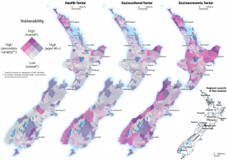 Nationwide vulnerability for Covid-19
Nationwide area-level vulnerability for adults aged 65+ years in New Zealand by health, sociocultural, and socioeconomic factors.
File size: 3.3 MB
Attribution: Wiki et al
Permission category: © - Only use with this story
Last modified: 01 Apr 2021 3:17am
NOTE: High resolution files can only be downloaded here by registered journalists who are logged in.
-
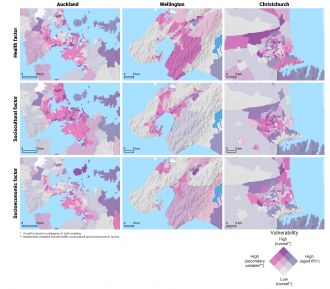 City-level vulnerability for Covid-19
Population vulnerability for adults aged 65+ years in Auckland, Wellington and Christchurch by health, sociocultural, and socioeconomic factors.
File size: 3.3 MB
Attribution: Wiki et al
Permission category: © - Only use with this story
Last modified: 01 Apr 2021 3:17am
NOTE: High resolution files can only be downloaded here by registered journalists who are logged in.
Media contact details for this story are only visible to registered journalists.
Expert Reaction
These comments have been collated by the Science Media Centre to provide a variety of expert perspectives on this issue. Feel free to use these quotes in your stories. Views expressed are the personal opinions of the experts named. They do not represent the views of the SMC or any other organisation unless specifically stated.